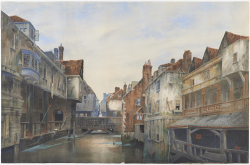
Situated between the Thames, the outflow of the River Neckinger at St Saviour’s Dock and two tidal ditches, Jacob’s Island in Bermondsey was a notorious slum in the early nineteenth century. This watercolour by James Lawson Stewart (1887) recalls Folly Ditch, immortalised as the site of Bill Sykes’s drowning in Charles Dickens’s Oliver Twist (1837-39). In the mid nineteenth century the poor residents had no source of clean water and many had to use water from the foul ditch into which they also discharged their waste. The water often ran red with pollution from the nearby leather tanning industry. Described in the Morning Chronicle as ‘the Venice of drains’, the area became a cholera hotspot in 1849.
© Museum of London
Secret Rivers, at the Museum of London Docklands from 24 May – 27 October, combines art and archaeology, with mudlarking, photography, film and much more to uncover the mysteries of London’s rivers, both those that flow above ground and those that have been buried beneath our feet.
The exhibition shows how London has been shaped by the Thames and its tributaries, and how they have in turn been shaped by Londoners. It explores how the Effra, Fleet, Neckinger, Lea, Tyburn, Walbrook, Wandleand Westbourne have been exploited for transport and industry, enjoyed and revered, and have influenced artists and writers.
Highlights include:
- The river Fleet; perhaps the most famous lost river, it flowed from Hampstead and Highgate to the Thames at Blackfriars Bridge. Its long history is told through previously unseen archaeological artefacts including rare surviving fragments of the 13th century Blackfriars Monastery, dissolved by Henry VIII in 1528. The remains were used to line a local well, which was excavated 450 years later. Other exhibits show that the river was a source of food (a medieval fish trap) before filling up with rubbish, including bones from Smithfield market and the waste from the many industries and houses along its banks.
- Themes of pleasure and poverty are explored through drawings and prints of the Neckinger and Westbourne along with archaeology associated with those rivers. One example is Jacob’s Island, the ‘capital of cholera’, an artificial island in the Neckinger at Bermondsey, created when factories and mills were established. By the 19th century, the river was polluted by the factories and the area was a notorious slum, surrounded by open sewers. More happily, when the Westbourne, which flowed from Hampstead to Chelsea Bridge, was dammed at Hyde Park, it created the Serpentine Lake and filled the ornamental canal in Ranelagh Pleasure Gardens, providing new water features for wealthy west Londoners.
- In recent years, there have been plans to bring buried rivers back to the surface. ‘Daylighting’ showcases two proposals to uncover the Effra and Tyburn, highlighting the passion and imagination of the Effra Redevelopment Agency and the Tyburn Angling Society who have campaigned to restore ‘lost’ rivers to south London and Mayfair.
The exhibition teems with curious facts about London’s rivers: for example, the Walbrook, which was buried in the 15th century, flows beneath the Bank of England and was spotted during building works there in 1732 and 1803; the Oval Cricket Groundin Kennington is shaped around a curve of the Effra and its seating banks were built using soil excavated when the river was covered; and the Westbourne flows through a pipe over Sloane Square Underground Station. You can even take a dip in a lost river, as Hampstead Ponds drain into the River Fleet.
